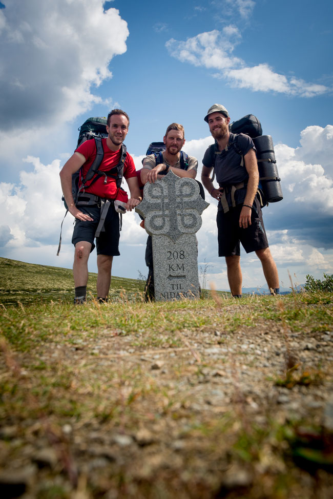
Around this time last year, Dave and I put together a short PDF guide to the St Olav pilgrim trails in Norway.
Since I posted it, a full English-language print guidebook has been released (available from pilgrim centres within Norway, and via Amazon), but our little guide is still getting a lot of downloads, so I thought it was worth an update.
Roger Jensen, the pilgrim chaplain and manager at the Oslo Pilgrim Centre, very kindly agreed to check it over, and has suggested a few revisions ready for the 2016 season.
Download a short guide to the St Olav pilgrim trail (updated Jan 2016) (PDF) (6.3MB)
As ever, I’m always keen to hear any feedback (either in the comments or by emailing contact@jolybraime.co.uk), and I’d like to wish the best of luck to everyone hitting the trail this summer. You’re in for an adventure.
Hi Joly
I hope you are well. We start our walk in a few weeks, could you let me know if you started East or West to Lillehammer? Also, did you keep a rough log of overnight stops? I have the new book but it is difficult to picture the trail and how long we should walk each day..
Cheers, Dave
David
Hi Dave,
I took the western loop up to Lillehammer, which was a nice route, though you do miss out on the Hamar ruins. If you’re desperate to see them then you can take the steamer across from Gjovik.
As for the overnight stops, my memory is pretty hazy, but to give you a VERY rough idea:
Day 1: just outside Oslo
Day 2: somewhere near Kleivstua
Day 3: a wood somewhere near Lamoen (we passed the most wonderful swimming hole in the morning – think it was Bonnerudtjern)
Day 4: just past Jevnaker
Day 5: Granavollen
Day 6: Einavatnet
Day 7: Kapp
Day 8: Some peculiar police dog training ground a bit past Gjovik, between the main road and the river
Day 9: Furuodden Camping
Day 10: Lillehammer
Day 11: Lillehammer
Day 12: think it might have been near Skaden Gard
Day 13: woods near Favang
Day 14: a bit beyond Bersveinholen
Day 15: a pilgrim lean-to with an awesome view near Ovre Skar
Day 16: a hunters’ gapahuk in the woods past Kvam
Day 17: Otta
Day 18: A bit past Vollheim Camping (good river swimming in the morning between Sel and Nord Sel)
Day 19: Arnkleivshoi (Dovrefjell)
Day 20: Somewhere up on Dovrefjell
Day 21: some ruins a bit past Kongsvold Fjellstue (Varstigsaetra maybe?)
Day 21: Smegarden Camping (Oppdal)
Day 22: somewhere a couple of hours beyond Oppdal (lazy day)
Day 23: past Havdal Gjesteheim
Day 24: somewhere on that long road stretch past Voll
Day 26: Skogheim pilgrim hostel
Day 27: not sure – it was a picnic spot with tables and stuff, but I can’t remember where
Day 28: Busklein? Well beyond Sundet Gard anyway (we opted for the boat rather than the road walk)
Day 29: Trondheim.
We usually tried to walk 20-25km a day, which suited us pretty well.
Let me know if you’ve got any more questions, and have a grand time. You’re in for a lot of fun.
Joly
indyjols
Great site, thanks!
We are planning our trip for next summer. Was drinking water ever tough to find?
Were there difficult river crossings?
Freda Herseth
Hello Freda, and sorry for the delayed reply. Water was always easy enough to find (away from the settlements there were plenty of clean streams, while most churches also had a tap outside where you could fill your bottle), and there were no difficult river crossings. Overall it’s a very safe and well-maintained route. Have a lovely trip!
indyjols
Thanks so much! we are tremendously excited to experience it all.
Freda
Freda Herseth